Why a Tidal Inlet Keeps Changing Its Outline
Learn why a tidal inlet changes its outline and how to read the water, sediment, and sheltered opening before choosing a useful place to observe it.
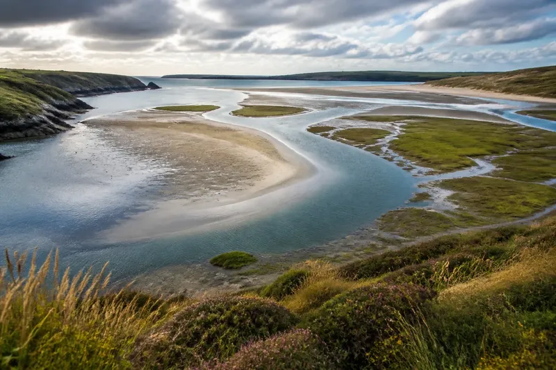
A tidal inlet can look like a different place between breakfast and an afternoon walk. Its outline shifts as water rises or falls, sediment moves, and the sheltered opening steers currents along the shore. To understand why a tidal inlet keeps changing its outline, look at the tide, the ground it exposes, and the shape of its entrance together.
What changes as the tide moves?
The waterline is the most obvious moving edge, but it is not the whole story. At low water, a broad flat may emerge and make the inlet seem wide and shallow. As the tide returns, water covers that ground, narrowing the visible shore and making the channel appear more sharply defined.
The same stretch can look unlike itself without any lasting change to its banks. A visitor standing on a path above the inlet sees a different pattern from someone near the water, where small channels and patches of wet sand become visible. Clouds, glare, and the direction of the light can further blur the edge between water and shore.
In a sheltered inlet, water often enters through a relatively narrow opening and spreads into a wider basin. That change in width affects how the flow moves. The entrance may carry a brisk current while water farther inside seems still, so the boundary between channel and shallows can be distinct in one place and indistinct in another.
How does sediment redraw the shore?
Sand, silt, gravel, and mud do not behave alike. Coarser material may gather in bars or along a bank, while finer sediment can settle across sheltered flats. Waves, tidal currents, streams, and runoff can all move material, but their influence depends on the local setting. A rocky inlet with little loose sediment will not respond like a muddy estuary.
When a current slows, it may drop some of the material it carries. Where it speeds up, it may pick up loose grains or keep them moving. Over time, these small shifts can alter a shallow channel’s apparent direction or expose a curved bar. A single visit may reveal the shape; it cannot by itself tell you whether that shape is new or part of a recurring seasonal pattern.
Plants can also make an edge seem fixed when the waterline is not. Salt-tolerant grasses may mark the upper reach of regular flooding, while exposed mud below them changes tone as it dries. Reading both edges—the vegetation and the current waterline—gives a fuller sense of the inlet than tracing the water alone.
Which way should you read the inlet?
There are three useful approaches, each suited to a different kind of visit. Choose based on whether you want to understand the changing water, notice the landforms, or compare the place over time.
Should you follow the tide?
Choose this approach if the inlet’s changing water level is what interests you. From a public path or another safe, established spot, watch where the current enters, where it spreads, and which flats disappear first; a tide table can help you interpret the timing.
Should you look for sediment patterns?
This approach suits a slower walk focused on the inlet’s physical shape. Look for a channel beside a bar, a sharp boundary between mud and grass, or a fan of deposited sand near a stream mouth, and compare those features from a stable viewpoint rather than walking across soft ground.
Should you compare visits?
Choose comparison if you want to distinguish a brief tidal change from a broader shift. Return to the same public viewpoint under similar light and tide conditions, then note what is visible; a phone photo or small sketch can make the comparison easier without implying that every difference is permanent.
Say you arrive at a sheltered inlet on a cloudy morning and see a narrow ribbon of water beside a pale sandbar. On a later visit near a different tide stage, you find the bar mostly covered and the channel harder to trace. If you record the tide stage and viewpoint, you can recognize that changing water coverage may explain the contrast before assuming the shore itself has moved.
What can the inlet’s shape tell you?
A narrow entrance can funnel water, while a broad basin gives it room to spread. Curving banks may guide currents around a bend; a stream entering from the land can add sediment or fresh water. These clues help explain why one side of an inlet may show a clear channel while the opposite side holds a wider fringe of shallows.
Still, an outline is not a complete map of the forces at work. A seawall, a natural rock sill, a nearby beach, or a river can change how water and sediment move. Two inlets that look similar from above may behave differently because their depth, materials, and connections to the open coast differ.
For a useful reading, separate what you can see from what you are inferring. “The water covers the inner flat” is an observation. “The sandbar has shifted” is an explanation that needs comparison with another view or visit. That distinction keeps a walk attentive without turning a momentary appearance into a claim about lasting change.
How can you choose a good observation spot?
Start with a marked public path, bridge, or established overlook that lets you see both the entrance and some of the inner basin. If one viewpoint hides the channel behind vegetation or a bank, a second accessible vantage can clarify the layout. Avoid crossing exposed mud, climbing unstable banks, or approaching fast-flowing channels; conditions can change while you are watching.
For a quick visit, focus on the waterline and the direction of flow. For a more thoughtful comparison, note the tide stage, weather, viewpoint, and visible sediment features. If you return in a different season, keep that difference in mind too: plant cover and runoff can change what the shore reveals even when the underlying shape is similar.
The most useful way to read a changing tidal inlet is to treat each outline as a snapshot, not a verdict. On your next visit, first identify what the water is covering, then look for the channels and deposits that remain visible. That simple habit makes the inlet’s shifting edges easier to understand—and leaves room for each shoreline to behave on its own terms.